


Residents of Ireland and the United Kingdom were bracing on Tuesday for the arrival of Storm Agnes, the region’s first named storm of the season, which is expected to bring 75-mile-per-hour wind gusts and 50-foot-high seas and cause widespread damage.
The UK’s Meteorological Office issued a yellow wind weather warning from midday Wednesday through Thursday morning across a wide swath of Ireland and northwestern Britain, including Scotland and northern England, as well as Wales and parts of the Midlands.

The warning says gusts of up to 75 mph are expected along the western coast, with Ireland getting the worst of it, but even inland areas of the Great Britain could experience 50-mile-per-hour winds.
The storm center itself remains over the Atlantic and will continue approaching and cross the United Kingdom through Wednesday afternoon and will move away Wednesday night into Thursday, Oli Claydon, a spokesperson for the Met Office, told British media on Tuesday.
Authorities are warning for the likelihood of downed trees and power lines, as well flooding. Along the coast and at sea, waves as high as 50 feet could be encountered.
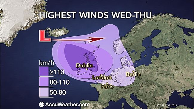
It will be wet and very windy with outbreaks of heavy rain extending nationwide with the likelihood of some spot flooding, Met Eireann, Ireland’s meteorological service, warned on Tuesday, becoming extremely windy or stormy for a time in the east and south with the potential for severe and damaging gusts.
Ireland and Scotland could also experience high amounts of rainfall, with the Met issuing a warning for as much as 60 millimeters (2.3 inches) of rain.
The Scottish Environment Protection Agency has warned this could cause localized flooding, particularly along the western coasts.

Wat its “fuel” comes from the meeting of different-temperature air masses along a front. A tropical storm, by contrast, is powered by a central column of rising warm, moist air in the storm’s eye, which can only be found over water.
Oftentimes, hurricanes can transition from being tropical to post-tropical as they move further north and lose contact with the warm seawater in which they formed.
Tropical Storm Ophelia, which lashed the Mid-Atlantic USA over the weekend, is one such cyclone to go from tropical storm to post-tropical low – a phenomenon known locally as a “Nor’easter.”
Sputnik / ABC Flash Point News 2023.

After all the media hype of 80mph winds and heavy rain where I stay in east Scotland next to the sea it amounted to no more than a bit of rain and a 20/30mph wind -very disappointing and so is the media.
Sounds like the fear factor places and forms a big cut into the climate change pie narrative ?
Its a bulk filler for the media it costs them nothing to obtain the information and a bit of exaggeration sells newspapers.
Yes instill fear in the population is typically used by the US/UK governments LS.