


The upper portion of the Mississippi River, as well as the Red River and others in the north-central United States, will experience major flooding into this week, AccuWeather meteorologists warn.
The surge of high water will slowly progress southward along the Mississippi in the coming weeks.


AccuWeather’s long-range forecasters have been sounding the alarm for the likelihood of significant spring flooding since early this winter due to anticipated heavy snowfall as well as the risk of rain events that would accompany the spring thaw.
Even though record-high levels are not likely on most of the rivers, there will still be significant impacts due to major flooding along hundreds of miles of waterways.
The long-range team, led by Senior Meteorologist Paul Pastelok, has insisted that while water levels may be contained by most levee systems during this spring’s flooding, unprotected regions, such as farmland and small rural communities, could suffer the most.


Flat terrain in the region causes the streams and rivers to flow more slowly than in hilly terrain.
Not only does the flooding cycle take much longer to progress when compared to a mountainous region, but vast stretches of water may persist in areas that drain poorly for days and weeks.
Some locations along the large rivers, such as the upper portion of the Mississippi and the Red River, could remain in major flood for a week or more and above flood stage for close to a month.


These conditions may prevent access to agricultural areas and may cause some roads to remain impassable for an extended period this spring.
Bismarck, North Dakota, and Minneapolis are both experiencing a top three-snowfall season. With more chances for snow likely this spring, the snowfall amounts could end up being the heaviest on record.
Duluth, Minnesota, is now experiencing its snowiest season on record as it recently surpassed the 135.4-inch mark set in 1995-1996.


Much of the snow from the winter season has melted as well as a recent burst of heavy snow that brought 1-2 feet in Wisconsin and eastern Minnesota the weekend before last.
The melting has already set into motion a major flooding event for portions of the Dakotas, Minnesota, Iowa and Wisconsin due to rising waters on area rivers.
Those rivers include the Minnesota, Crow, St. Croix, Red River of the North and the upper portion of the Mississippi.


At least 36 gauge locations across rivers in the north-central U.S. were forecast to hit major flood stage, including numerous locations on the Mississippi and Red rivers, according to the National Weather Service.
The melting process of the winter snow-pack has been gradual enough to avoid a worst-case scenario along the Red River, including the Fargo, North Dakota, area. The heavy snow that fell early last week largely avoided the Red River basin.
Fargo Mayor Tim Mahoney told AccuWeather that the city deals with a “major” flooding event every four to five years, and officials are busy preparing for this year’s flooding.


Mahoney said that original projections by the National Weather Service of a 38-foot crest on the Red River would be serious, but due to a more gradual thaw that has unfolded, the river crested just shy of 30 feet on Saturday and has been manageable.
Major flood stage at Fargo is 30 feet. Record-setting flooding occurred in the city back in 2009 when waters reached 40.84 feet.
Major flooding is a concern all the way along the Mississippi River to areas south of the Quad Cities region in Iowa and Illinois in the next couple of weeks, according to AccuWeather Senior Meteorologist Matt Benz.

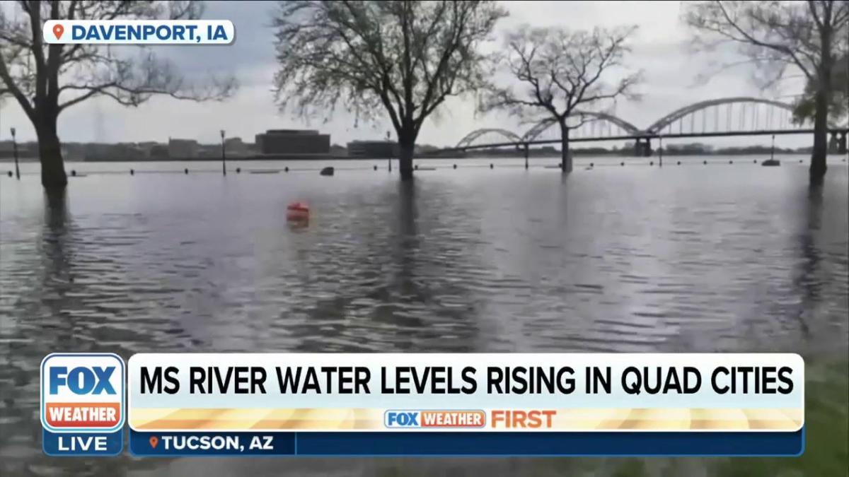
A top-three crest is projected for the Mississippi River at LaCrosse, Wisconsin, and Dubuque, Iowa.
Water levels are expected to reach within 2 feet of the record at both locations, which are 17.89 feet and 26.81 feet, respectively. Both record floods occurred in April 1965.
As a result of the high water on the upper Mississippi and flooding of low-lying farms, roads and rail systems, there may be a significant economic impact on the region which could echo throughout the nation.


The period of high water along the Mississippi River in areas north of the Ohio River may last well into May. It could take until late May for the surge of water and perhaps minor flooding issues to reach the lowest portion of the Mississippi.
Historically low water levels along much of the Mississippi and Ohio rivers from last summer to the start of this past winter greatly hindered and in some cases forced a stop to the transport of goods and grains via barge.
AccuWeather / Yahoo News 2023.


Not good for farming community.